Innovative Environmental Protection | Only in the Movies?

At first glance, Heracleum mantegazzianum (commonly known as the giant hogweed) might appear desirable – like a decorative, ornamental plant that would be right at home in your garden. But don’t be fooled by this towering beauty. It’s often regarded as one of the most toxic plants in the world! We set out to tackle the deadly giant – the NTT DATA Business Solutions way. Read on to see innovative environmental protection in action.
It Might Sound like the Premise for a Horror Movie – but for Some Landowners, It’s a Reality…
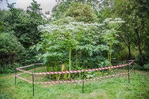
The giant hogweed is a noxious perennial. A distant relative of the humble carrot, it can grow to up to 15-feet tall and produces a clear phototoxic sap that can cause blindness if it comes into contact with eyes. It can also cause severe burns and blisters, should the sap in combination with sunlight, meet the skin.
Landowners and local councils are tasked with eradicating the invasive plant. Not only is this time-consuming, but it exhausts a lot of their resources. What’s more, simply locating the plant is easier said than done.
It Might Sound like the Title of the Latest Sci-fi Movie, but NTT DATA Business Solutions Makes It a Reality…
Imagine if the process of sourcing the plant could be automated. That’s exactly what we set out to do – we began to lay the groundwork for innovative environmental protection. We utilized drones and image recognition technologies to identify the plant using an artificial neural network.
A first step involved screening of large areas of land. NTT DATA Business Solutions had partnered with a renowned drone manufacturer to assist a number of Danish municipalities and landowners in streamlining this process. The drones provided high-resolution images; it’s these pictures of open flatlands and forests that formed the basis for further analysis. A partnership with the local communities meant that we didn’t have to arrange our own biologists to conduct the labeling process of the images. This system-based research is already a major improvement on the aforementioned manual detection methods of the past.
Machine Learning and Neural Networks Are Set to Take Things to the Next Level…
In a pilot project with Danish municipalities Hedensted, Randers, Kolding, and Viborg, intelligent algorithms are now being used to detect the non-indigenous weed.
A subset of images is used to create a training pipeline where the drone images are analyzed. Images are divided into a training bucket and a validation bucket. The content from the training bucket is used to train the algorithm. This iterative process can be repeated using an adjusted algorithm, in case results do not meet expectations. If the algorithm produces a positive result, it is deployed in production. If unsuccessful, the algorithm is retrained.
As a result, we were able to improve our detection rate of giant hogweed. As we are beginning to discover, the same process can be repeated for other visible species. That truly is innovative environmental protection!
The use of artificial intelligence in the analysis phase leads to improved cost efficiency and effective screening for land that is difficult to access or scale by foot. In addition, the manual process could previously only be carried out by specialists and biologists – but now an AI application allows non-specialists to carry out a substantial part of the same work. In actual fact, we were able to achieve better results using algorithms as opposed to manual human identification.
Artificial intelligence, machine learning, big data, and drones: The technologies for innovative environmental protection were already in place. However, to make it a reality, our challenge was simply providing enough labeled images to be able to train a high-quality neural network. Take the municipality of Viborg, for example. In this area alone, our drone photographed over 1,400km² of land (larger than New York City!). Every high-resolution image taken covers about 5m². Due to the large amounts of data, we curated a modern data platform in which all relevant data could be processed and stored efficiently. Therefore, another challenge lay in creating a concept for the management of all this data!
To ensure effective use of the technologies involved in the project – and of course to retrieve results – it was also important that we combined the industry expertise and technological know-how.
Probably the biggest technical challenge we faced was in combining the right tools and services. Team members are still discovering more about the types of technology used in this project. These new tools and services are paving the way for more interesting projects and opportunities in the fields of artificial intelligence and machine learning. What’s more, innovations such as these are always fun to work with and they can produce rapid results.
Our NTT DATA Business Solutions team provided field workers with the information extracted from the drones via an app. The app was created on a cloud-based platform in just a matter of days. We were able to review the images as soon as we received them. And going forward, feedback from the field suggests that the algorithm for image recognition will be refined even further. We can therefore look ahead to more projects for innovative environmental protection.
Curious? Don’t hesitate – contact us today!